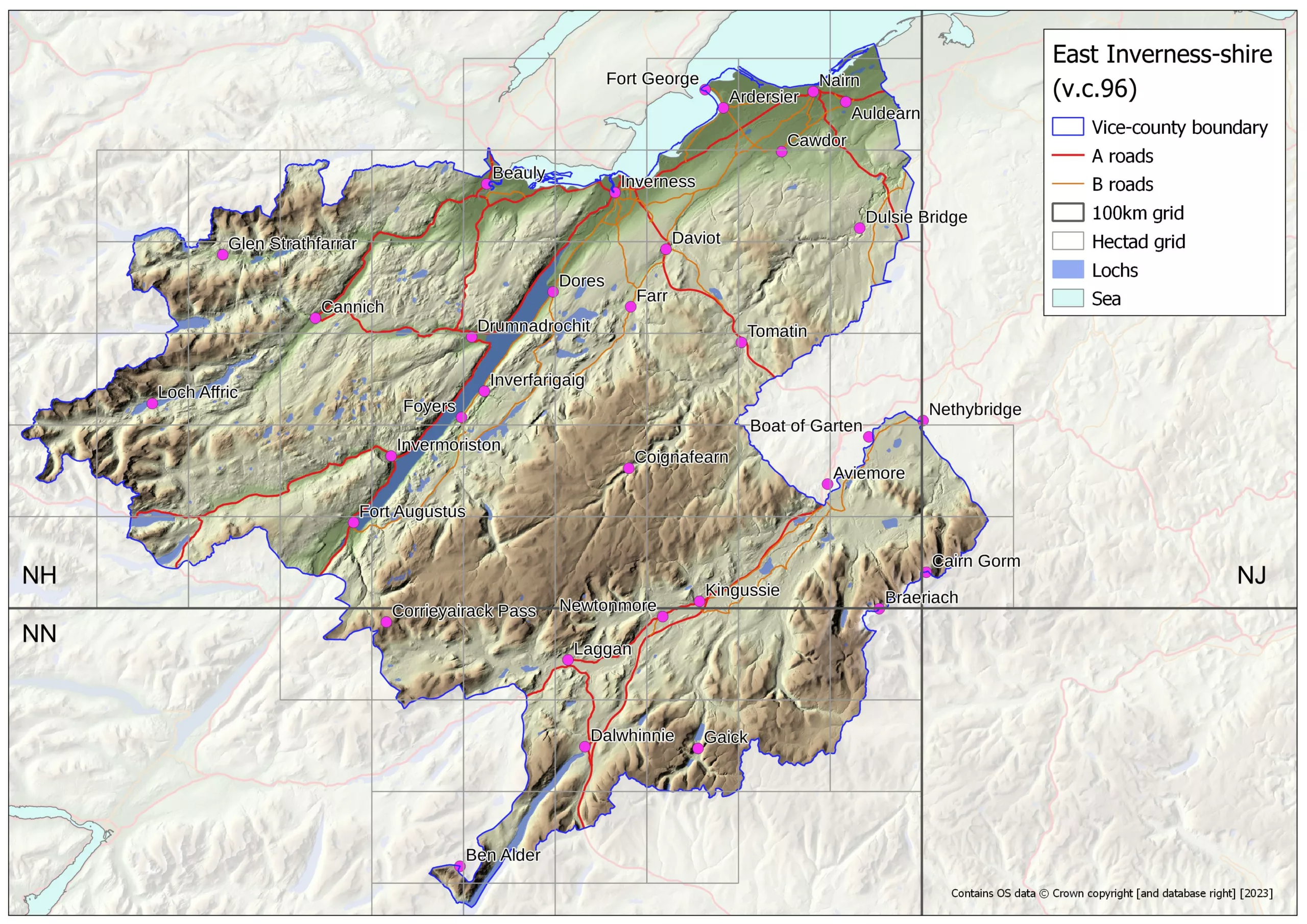
Easterness, also known as East Inverness-shire, is the largest vice-county in Great Britain and Ireland, being that part of the old county of Inverness-shire north-east of the watershed between the eastern and western sides of Scotland. It covers all or parts of 73 hectads, 1364 tetrads and 5176 monads. It extends from sea level, beside the Beauly and Moray Firths, to 1296m altitude on the summit of Braeriach, the third highest mountain in Scotland. The vice-county includes 41 Munros (mountains in Scotland over 3000 feet), 21 Corbetts (mountains in Scotland between 2500 and 3000 feet) and 17 Grahams (mountains in Scotland between 2000 and 2500 feet). Mean annual precipitation varies from 4300mm in the extreme west of the vice-county, to as little as 650mm in the extreme north-east.
Mary McCallum Webster's Flora of Moray, Nairn & East Inverness, published in 1978 by Aberdeen University Press remains an exceptionally valuable account of the flora of v.c.96 (and of v.c.95, Moray). It remains the primary source of information on the earliest records for the vice-county. Since the publication of this Flora, 312 additional taxa for v.c.96 have been recorded over the period 1978 - 2023. These additions are listed in this Excel file - vc96 taxa not in Flora updated to 2023.
There are records for 1824 taxa in v.c.96, of which 1128 are native to the vice-county. 626 taxa qualify for inclusion in the v.c.96 Rare Plant Register. These include a remarkable number of red listed (above Least Concern), nationally rare and nationally scarce taxa, including 103 taxa endemic to Scotland, Great Britain or GB and Ireland.
- A v.c.96 Checklist & Rare Plant Register taxon list, in Excel format, is available here - vc96 East Inverness-shire - Checklist & Rare Plant Register taxon list - 10th March 2023, alongside this January 2024 checklist update.
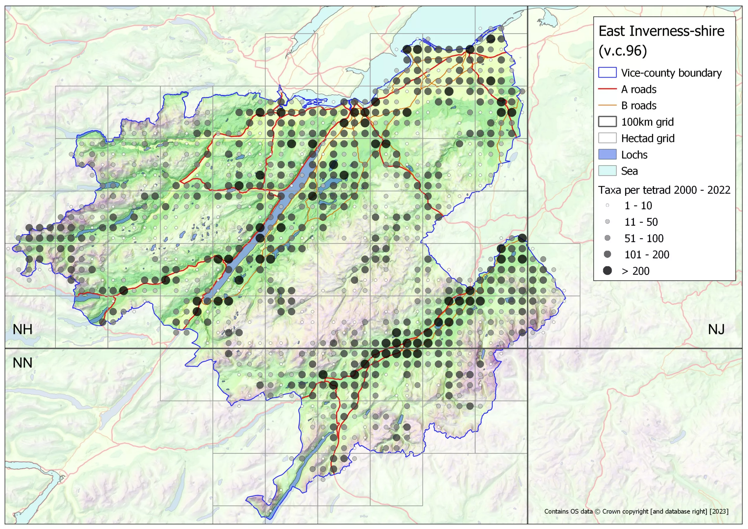
- A series of maps of v.c.96 have been created using QGIS 3.22. Maps 1-5a and 9 use a digital terrain model (DTM) as a backdrop, created using the Ordnance Survey Terrain 50 dataset. These can be downloaded from the 'Maps of v.c.96' to the right.
- Tetrad distribution maps for all RPR taxa recorded 1970 - 2023 are available in this folder.
- Tetrad distribution maps for Near Scarce native & archaeophyte taxa recorded 1970 - 2023 are available in this folder.
- An analysis of the altitudinal range of all vascular plants & Charophytes in v.c.96, in Excel format, is available here.
Recording in v.c. 96
Records of plants in the wild are always very welcome, and should be submitted to Andy Amphlett (contact details above). As far as is practicable, in v.c.96 we prefer to collect records of all taxa at minimum 100m precision (using a GPS). If that is not possible, then records should be at minimum monad (1km) precision. Andy Amphlett can advise on how best to submit records, format etc..
As can be seen (Maps 4, 5, 5a and 7) there are many areas within v.c.96 with few or no plant records. Upland areas at intermediate altitudes, c. 400-800m, are less well surveyed than lowland and (some) montane areas. Records from such locations would be especially welcome. However, records from any part of the vice-county, are also very welcome.
Please record all plants in the countryside, i.e. everything outwith gardens, parks and cemeteries, apart from cultivated crops in fields and allotments, or planted as game cover and wildlife strips. If you can be sure that something is planted in a wild situation, please indicate that as part of the record. Please ignore any formal plantings in municipal flower beds, at the entrances to towns and villages etc.. Please do record planted street trees, plantations and shelterbelts. Within gardens, please record anything growing wild (i.e. not originating from plants that were originally planted). In parks and cemeteries do record any species that are thoroughly naturalised. There are always grey areas when it comes to recording. If in doubt please ask!
Further information
To obtain a list of taxa recorded in a hectad or tetrad use this webpage - https://database.bsbi.org/reports/sitetaxa.php. If you enter a grid reference at tetrad or greater precision, the tool will return the taxon list for the tetrad. For example, enter NH667454 (Inverness train station), the taxon list for tetrad NH64S will be returned - https://database.bsbi.org/reports/sitetaxa.php?gridref=NH667454&minfreq=&minyear=&maxyear=2000.
To obtain or check grid references use this webpage - https://www.cucaera.co.uk/grp/. Zoom in to show the OS 1:50,000 and 1:25,000 maps.
For an overview of the national distribution of any plant go to the Atlas 2020 website - https://plantatlas2020.org/.
County Recorders
Maps of v.c.96
- Map 1 vc96 base map
- Map 2 vc96 base map & place names
- Map 3 vc96 base map & hectad labels
- Map 4 vc96 base map & taxa per tetrad all years to 2023
- Map 5 vc96 base map & taxa per tetrad 2000 - 2023
- Map 5a vc96 base map RPR taxa per tetrad all years to 2023
- Map 6 vc96 Land Cover 2019
- Map 7 vc96 Land Cover 2019 & taxa per tetrad all years to 2023
- Map 8 vc96 mean annual precipitation 1991 - 2020
- Map 9 vc96 mountains (Munros Corbetts Grahams)

